Thursday August 19th
2004 Back from Colorado
I just got back from the final hike of the summer—200 miles on the Continental Divide Trail and Colorado Trail. This was a sort-of faculty trip. My hiking companions included Biology professor Burt Webb and his son, Mason, retired science professor, Jeannie Argot, and philosophy adjunct professor Cherie Horst. The Webbs were already on the CDT several days by the time the rest of us flew out to Denver where IWU grad Craig Coe met us and took us up to Grand Lake Colorado where the whole team started out on our trek.(well, it took several hours to find each other first, then we ate a tableful of food before leaving town).
Pushing around Grand Lake and some other lake-I-forgot we camped just as darkness fell. The second morning, after a strong morning’s walk Cherie Horst got separated from us and the rest of the afternoon we played backtrack-and-seek-each other games but never reconnected. We had arrived at a confusing set of roads and car-campgrounds—which confirmed once again that it is “easier to get lost in town then on the trail.” We never found Cherie (who had actually gotten ahead of us we discovered from one car camper, then got off the trail and we passed thinking we were catching up to her the rest of the day. (Cherie simply hitched down that road and got a motel.)
The next afternoon while crossing another dirt road in a pass Cherie showed up thanks to a hostel lady who was generous with her car. That second night we slept on the most terrible “level spot” Burt Webb ever picked. Well, it was almost level, but was packed with hummocks of alpine grass clumps. I called it the “puzzle camp” since my body only fit one way around the hammocks. Cold Night above the timberline. My water partially froze over night producing a delicious “slushy” of my cherry Kool-Aid. After a morning huffing across the tundra, Cherie had to bail out due to sickness. She then walked down the tundra to a parallel dirt road in the valley and out to civilization, where she eventually found a way home to Indiana and has recovered.
The four of us remaining climbed the most spectacular peak of the trip that day then proceeded to a section of the CDT where the “trail” exists only in the minds of the Forest Service and on maps, but not actually in the real world. After climbing several peaks, crossing valleys, and heading up then down then up again old mining roads, we finally ran out of water just before coming to the ruins of an 1840’s mining town. There amidst the ruins was a single rebuilt log hut occupied by “Many Summers” an obviously white women that claimed to be an Indian with ancestors who worked in the mining camp. Quite an interesting lady whose mental cylinders seems to fire in random order. Whatever, she gave us a gallon of water and instructions on how we might actually get out of the mountains to a road again. The instructions turned out to be screwy. At dark we did finally find a stream and camp, admitting we had walked over 20 miles and were now hopelessly lost. Just after the sun set two wild-looking men wandered in our camp sporting dreadlocks, both with fear in their eyes. They too were lost and said they’d walked all day only to wind up at this very creek they’d left the day before. “You can’t get out this way.” We sent them on their way back to “Many Summers.” Then we went to sleep having about decided we needed to skip this 30 miles section of the CDT where the trail has “not yet been fully developed.”
The next morning we retraced some of the steps from the day before and finally found a path which led to a logging road which led to a dirt road, which finally led to a paved road. We had decided by then to simply reverse the direction of our hike—going down to where we planned to finish (Leadville) and hike North, linking up back to the other end of this unfinished “route” and maybe even (if we made good time) take the Colorado Trail right back to Denver.
The CDT and the Colorado Trail run together for several hundred miles of Colorado, so hopping over to Leadville gave us a week on the shared trail and time to decide. The CT is far more tame than the CDT—and it is actually even marked so hikers can know where the trail is!
Hitch hiking of course produces even more stories than backpacking—especially for Jeanie Argot—this was her first time to hitch. It took two rides to get to Idaho Springs and the four of us were hitching from there to Leadville when a thirty-something attorney moving from Wisconsin moving to California stopped to ask. “where ya’ headed?” “Leadville” we replied with hope. “You got it—think you can fit in here?” he asked. Bending over to inspect his ordinary-sized car we saw the back seat crammed full and even with the top of the seat. The passenger side front seat was also stacked up even with the window. “Sure, we said” more in jest than faith. “Is there any space in the trunk?” we asked? “Nope if I open that it will explode and we’ll never get it shut again.” Our Good Samaritan “Hershey” then urged us to “Move anything back there” and we went about re-packing his car, jamming, squeezing, compressing, stacking until three of us jammed into less-than-half of the back seat, our packs on out laps, and Burt folded his long legs in/among/on the things in the shotgun seat. Hershey (“Like the candy bar—OK?”) took us the 90 minutes to Leadville where we caught our breath and started out again, Northbound this time.
The Colorado Trail is perfectly marked so getting lost was now out of the question. We hiked Across tundra above the timberline often from Leadville to Silverthorne—the same re-supply stop we intended to use when we originally were headed south—only this time we were coming in northbound. What a delight it is to arrive at the post office and get letters or packages. Brownies from Sharon, light weight trail goodies from John and Mandy, all the fixings for S’mores from Kathy and Dave. Even a wonderful box of nuts and snacks from Irinia (Hannah) Frambro from Texas. And of course always a love letter from Sharon. Knowing that we’d not make it though the 30-40 miles of “developing trail” we calculated our speed and time decided we’d stay right on the Colorado Trail and walk right back to the Airport in Denver a hundred miles away. Burt Webb and I had hiked the Colorado Trail from Leadville to Durango three years ago and this would give us the opportunity to finish up that 479 mile trail (well, not exactly we still would have a 22 mile section from Twin Lakes to Leadville). So we all agreed at Georgia Pass we’d stay on the Colorado Trail and walk right down to the edge of Denver. But it would mean walking over 20 miles each day and probably doing one “marathon day” of more than 26 miles. But we were in good spirits and decided to try.
It went easier than we thought. Our youngest hiker, 13 year old Mason Webb did not slow us down a bit, but actually led the way uphill, and never complained a moment on this 200+ mile trek. He was a master at knowing the trail data –how many miles we had come, how many to go…we dubbed him “Data Book” as a trail name. Our oldest hiker, 68 year old Jean Argot did not slow us down either. She was steady and consistent, always the first to have her shoes and pack on in the morning and after every rest stop as if she might be saying under her breath, “Well, aren’t you ready to go yet?” . As a trail name we dubbed her the old nickname her students used to give her—“The Hammer.” Of course Burt Webb is a great runner so that left me to be the slow one. (There always has to be a slowest hiker in a group—my turn.) I fulfilled my role with honor. For me this was a hard hike. I usually have a few students travel with me and they almost always carry some of my load, usually three pounds per student. On this hike I had to do my own heavy lifting, so I trudged along usually at the end of the line. To top it off I was recovering from a hip injury so I was popping 12 Advil a day to dull the pain. But we made it! We never dropped below 20 miles a day and we even put in a 26.2 mile Marathon day—the first backpacking marathon for both Mason and Jeanie.
Arriving at the edge of Denver we met a mountain biker who said, “Gee, I’d love to take you to the airport bus but all I have is a Honda Civic.” Of course Hershey had taught us that an empty Honda Civic would be spacious compared to a full Toyota—sure enough, we crammed in and got to the airport by dark—days before our planned ending. Of course Continental seldom flies in the evenings for some strange reason, so we slept all night at the airport and got a morning flight home yesterday. Well, not all of us. Burt and Mason Webb had booked their flight through www.hotwire.com saving about $5 each on their ticket price (under the Orbitz cost) but discovered to their chagrin that they could not even pay the $100 fine to change the ticket as the rest of us did—hotwire tickets are dead if not used exactly as purchased. So Burt and Mason rented a car and drove from Denver to Indiana, while Sharon met the other two of us at the airport. (Bye bye using hotwire.com for hiking—when you almost always finish early or later than planned.)
So now I’m home for the fall semester. I’m tired. So, today all day I grunged around all day. I ate 6 pounds of tomatoes for breakfast, nine ears of corn for lunch and it is almost supper time—I still have not taken a shower or got out of my pajamas. I’m taking the day off—I walked 200 miles to get this rest! I’ll start answering email tomorrow maybe.
I leave at 6AM tomorrow for Colorado.. tomorrow night I will sleep on the Continental Divide Trail near Greand Lake Colorado. The first leg of this trip takes me 140 miles through the high country to the only town we’re stopping in—so if you want to send a note or card make sure it gets there by Saturday August 14 when I should be there to resupply (or maybe if we’re slow Monday the 16th. How to address it:
Hold for CDT Hiker
c/o General Delivery
Tuesday August 3rd
2004. Getting ready for the CDT
Sharon is in Virginia this week doing the academic thing—delivering a paper in servant leadership to a bunch of other PhDs. I’m here finishing up moving—bringing all the boxes in from the garage and unpacking them. I leave Friday for hike #3—this one on the Continental Divide Trail in Colorado. The only hitch was an awful throbbing tooth which turned out to be an abscessed tooth that kept me up the last two nights waiting for my dentist to return to work Tuesday. When he opened this morning I was in the parking lot. Luckily Earl Jackson is a friend and arranged a root canal within an hour and now I am happily typing this with enough codeine in my system to have sanctified me (if sanctification is supposed to produce passive and pleasant people at least). On Friday I leave to hike a couple hundred miles from Grand Lake Colorado to Leadville with several other faculty members: Burt Webb, Jean Argot, Cherie Horst and Burt’s son, Mason. I shall return for faculty retreat. This is my last “fling” with the mountains this summer :-(
Monday July 26,
2004 We’ve moved
I’ve been barely even checking email recently if you’ve written. We just moved. Not far—just across the . Our neighbors retired and moved to Indianapolis and we bought their house. Gee, it feels like we’re rich—the home has two bedrooms and a “study” but the real wealth (for me at least) is a double car garage! I have filled one whole side with tools—I see no reason to park automobiles under a roof. Sharon does however so she’ll park in the other side. So, I’ve painting, doing electrical work, preparing hardwood floors, and moving my tools and sports equipment to this new house and last week our son David and his family helped us move in. Right now I’m unpacking boxes and setting up the house since I leave on my third backpacking trek of the summer August 6—on the Continental Divide Trail in Colorado. For now I’m only checking email as the bath tub is filling up. ;-)
Me moved from our “cottage” at 4636 S.
Wigger
…across the street to
Tuesday July 6,
2004 Back from the John Muir
Trail—trek #2 with Sharon in the high sierras
Woah! Great hike
with Sharon. We left right from General
Conference and flew to
California and within 12 hours we were above 10,000’ backpacking in the High
Sierras. Great vacation! We backpacked in from Cottonwood pass, then
climbed up the West route to the top of Mt. Whitney—the highest mountain in the
“lower 48.” Then we continued on the
John Muir Trail over Forester Pass and
Kersarge 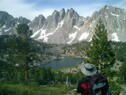 Pass
then hitchhiked down to Independence, Lone Pine and back to our rental car 75
miles away. As always the hitchhikes
are as fun as the hike on trips like these.
This was the first backpacking Sharon has done in 15 years but she did
fine—we didn’t break any records but at our age “you win if you finish” and we
finished. Now I have one month at home
before the final hike of the summer—on the Continental Divide Trail in Colorado
in August. A few of my favorite
pictures from the JMT:
Pass
then hitchhiked down to Independence, Lone Pine and back to our rental car 75
miles away. As always the hitchhikes
are as fun as the hike on trips like these.
This was the first backpacking Sharon has done in 15 years but she did
fine—we didn’t break any records but at our age “you win if you finish” and we
finished. Now I have one month at home
before the final hike of the summer—on the Continental Divide Trail in Colorado
in August. A few of my favorite
pictures from the JMT:
Thursday June 3,
2004 -- Pacific Crest Trail report Trip #1 –a desert walk with Sam
Bills
I came home from the Pacific Crest Trail. Today is our anniversary. Boy am I am ever exhausted—when I left the Trail in Palm Springs it was 108 degrees. I don’t like hot hiking—I like cool mountains. Walking the first 150 miles with Sam Bills (from the Mexico line to Anza) was the highlight of this trip. We talked theology, church history and worship. Sam has become quite a student at Azusa seminary, and was able to telegraph to me lots of Donald Dayton’s thinking while we walked, a real treat. Luckily some wonderful anonymous “trail angels” left jugs of water near roads—which was good, we only saw one trickle of water form Mexico to Palm springs—without them we’d have been dray, dead or both. Sharon came and visited us in Anza, right when Sam left.
The rest of the trip was a drag. The drought in Southern California left all the natural springs and creeks dry except three in the first 200 miles. After Sam left I had a hard time keeping focused. And to top it off I wound up with severe electrolyte imbalance, drinking too much water and losing my appetite so that my sodium and potassium levels dropped so far that my muscles went haywire—on one day I walked 15 hours and got only 18 miles-half my normal speed. I struggled on forcing down salty snacks and eating nothing else and it only got worse. I finally made it to Interstate 10 and Palm Springs where I could catch a bus to San Diego and fly home in time for our anniversary, cutting short my intended hike by almost a week. Next year I will probably start at Interstate 40 near Mojave and hike south to I 10—that will complete the entire 2600 mile Pacific Crest Trail for me. And, one more thing—I will do the entire part with some students or others—I’m done walking the desert solo! OK, next May I head south from I40—just 330 miles left—who will “leave their nets” and come with me?